Use cases
September 23, 2026
SiteCom: Correlation in Live - confident markers while drilling
Industry: Oil & gas
Asset type: Wells
Solution: Operations & performance
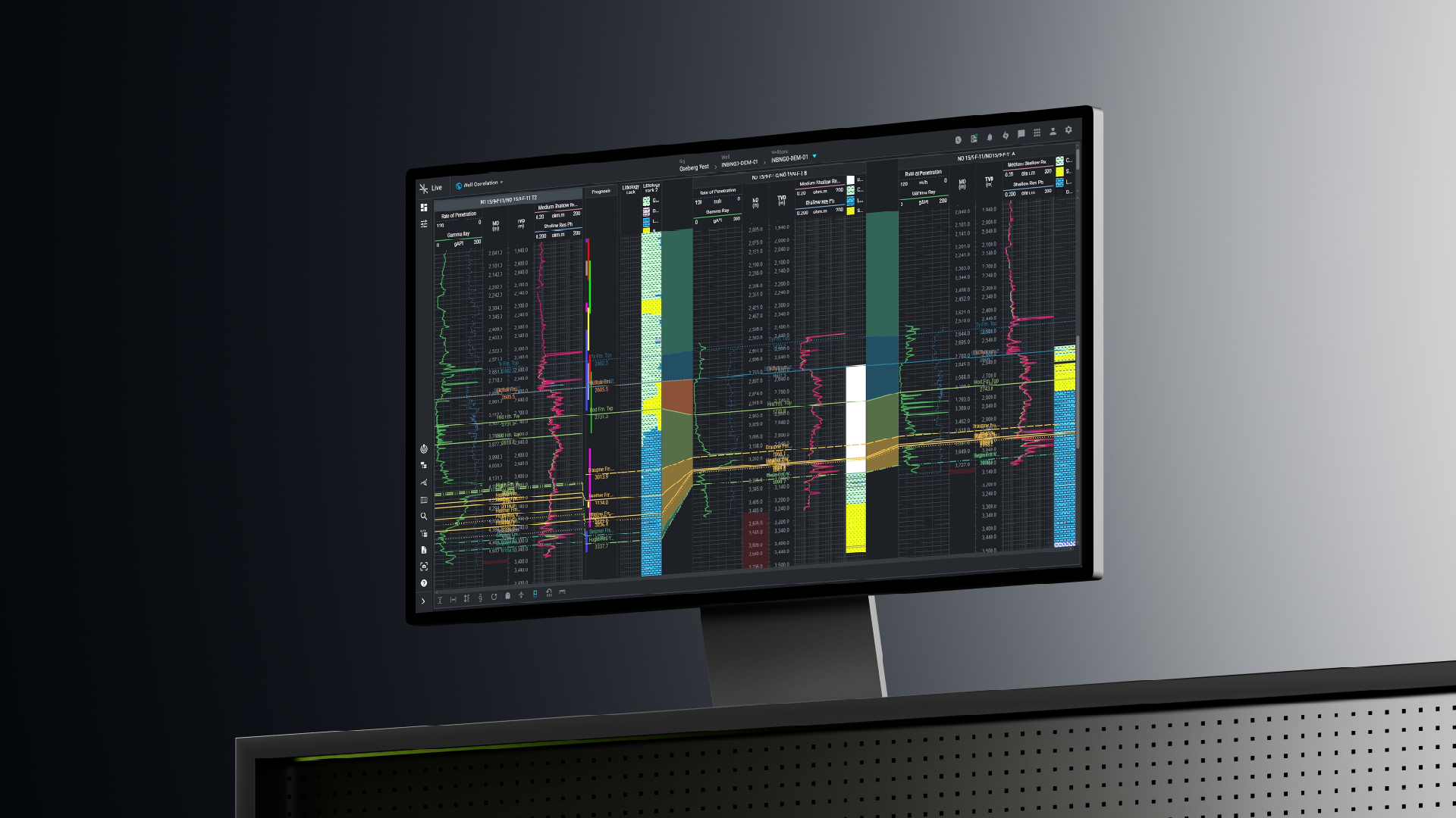
The correlation workspace in SiteCom - a real-time view of formation tops as they're occur.
Background
An operations geologist has one question that never really goes away: where, exactly, is the next formation marker? Get it right, and the drilling team knows where they stand in the geological column. Get it late, or miss the pick entirely, and the well can drill straight into a loss zone, or into a formation the mud program was never designed for.
The method itself hasn't changed in decades: compare the current well against its offsets. What has changed is the clock. Correlation used to be post-well work, done at a workstation with final logs. Now it happens while the bit is turning, and the answer has to arrive before the next stand does.
Correlation, one of the applications in SiteCom Live, was built for that job.
The challenge
Why real-time correlation is demanding
On paper the task is simple: line up gamma, resistivity, ROP, gas shows and cuttings lithology - against the offset wells, check where the actual markers landed previously, then confirm or move the prognosed markers ahead of the bit.
Geology rarely cooperates:
-
Formations pinch, thicken and dip between wells, so a pattern spanning fifty meters in one well can show up squeezed into twenty in the next.
-
The current well only has data down to the last logging point, so the interval that matters most, the one just ahead of the bit, is exactly the one with no measurements.
-
There is a deadline: a marker placed after the bit has passed it is worth nothing.
Now: how many applications does the operations geologist touch today to manage formation tops?
The honest answer is rarely "one".
How teams work around it today
Most teams rely on one of three patterns:
-
Full geoscience desktop platforms. These have mature correlation tools with cross sections. But, they're built around project files: logs must be exported from the real-time environment, imported and conditioned before any correlation happens. The interpretation may be powerful, but it lags the bit; these platforms were designed for modelling and post-well work, and are heavy to keep updated while drilling.
-
Specialist geosteering applications. Genuinely real-time, but built for a different problem: keeping a lateral inside a target zone using synthetic logs and bed-dip models. Stratigraphic marker placement across multiple offsets, prognosis management and loss-zone avoidance, the operations geologist's actual job, sits upstream of geosteering, and these tools weren't designed around it.
-
Manual assembly. Exported curves, marker spreadsheets and correlation figures rebuilt by hand for the morning report. It works, until the morning the geology moves faster than the workflow.
Correlation closes this gap: correlation-grade interpretation tools running directly on the live data stream, built for the marker workflow and nothing else.
Without a solution, every data consumer builds its own “data fixing” pipeline from scratch, and when a new vendor changes a mnemonic, the pipeline most likely breaks.
What Correlation does
The workspace puts the real-time well and its offsets side by side. Vertical log tracks carry gamma, resistivity and other measurements, color-coded per curve. Formation markers run as labelled horizontal lines across the tracks. Risks sit as color-coded icons spanning the depth interval they apply to. Zooming is instant; nobody waits on data to load.
Marker management is the heart of it. Markers can be placed by pointing and clicking at depth, dragged to a new position directly on the track, or edited through the settings table. TVD and MD are handled at the same time, with Live doing the conversion, so the geologist picks once and both depth references stay consistent. When adding a marker, previously used names are listed to choose from, which keeps typos out of the formal marker set, a small thing that matters a lot when formation reporting is a regulatory requirement, as it is for operators in Norway.
Interpretation tools
Around the core sits a set of interpretation tools:
-
Ghosting: Curves and formations from an offset track can be duplicated and overlaid onto the current well, so both datasets are visible at once. The ghosted interval can be squeezed or stretched, keeping the comparison valid when formations in the current well are pinched or expanded relative to the offset.
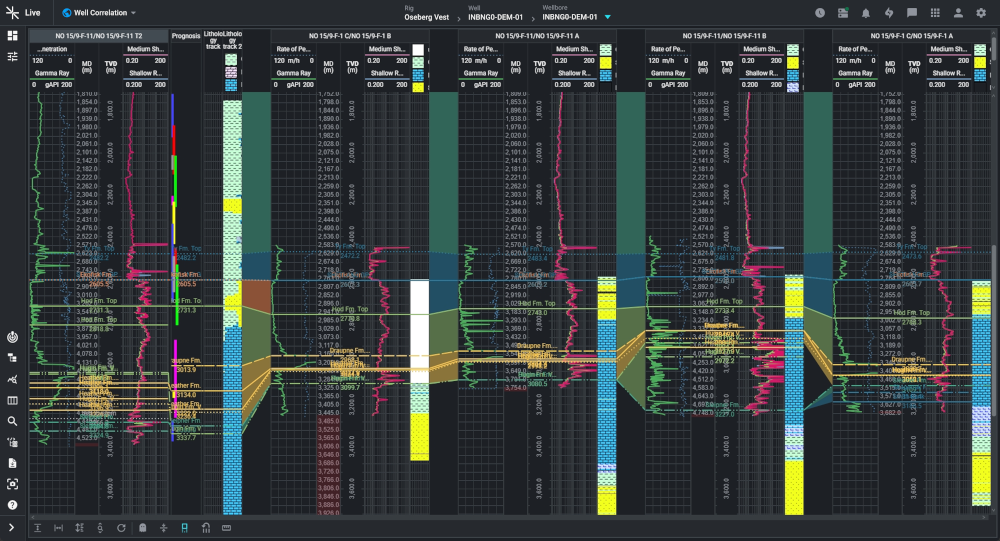
Ghosted offset curves can be squeezed or stretched to match the current well, keeping the correlation valid where formations pinch or expand.
-
Flattening on markers: Hover near a marker, select it under the Flatten function, and every displayed well resets to that datum. The result is a zoomed-in, marker-by-marker view where small differences in the surrounding intervals become easy to see.
-
Offset Well Manager: The full database of offset wells is a few clicks away, with no manual data preparation and no file loading. Wells can be added, removed and rearranged across the workspace so the strongest correlations sit next to the current well, and administrators can copy display settings across wellbores to keep teams working from a consistent view.
-
Custom markers: Ad-hoc markers for spot checks, kept separate from the formal marker set.
-
Projection to bit: The interval between the last logged data and the bit is projected forward, giving the geologist a working view of the un-logged section and a basis for realigning upcoming markers before the data confirms them.
Projection to bit
Extending the interpretation into the interval where logging data has not yet been acquired
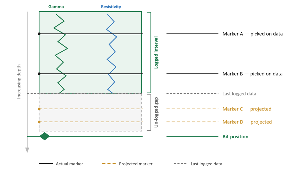
Projection to bit gives the geologist a working view of the interval where logging data has not yet been acquired.
-
Formation zoning: Formation intervals can be zoned out visually, making the spread of each layer across the panel readable at a glance.
-
Risks, planned and actual: Risks encountered in offset wells are carried onto the prognosed tracks of the current well, color-coded by category and severity. If an offset took losses in a formation, that risk sits on the same formation ahead of the bit. New risks can be identified, documented and edited as the well progresses, so risk awareness is a live picture rather than a static checklist from the drilling program.
One interpretation, shared instantly
This is where being part of Live pays off. The moment a marker is saved in Correlation, it flows into the formation marker table and exists everywhere in Live. A drilling engineer on the rig sees the verified formation depth and its associated risks on their own dashboards, or in Trip Risk, Operations Review and elsewhere in the platform. Nobody exports an interpretation and emails it around; nobody re-enters a top into a second system. One pick, one source of truth.
Upstream, the same platform does the preparation work. Curves arrive standardized through the Global Mnemonics Hub, so a gamma ray from one service provider lines up against a gamma ray from another without renaming or unit conversion. Data Quality monitoring runs before a curve ever reaches the correlation panel, so the geologist is interpreting validated data, not discovering a flatlined channel mid-correlation.
A standalone correlation product could not make that claim. This one can, because the interpretation and the operation live in the same place.
From interpretation to prevention
The value of this workflow is measured in what doesn't happen. A marker identified one stand early is the difference between adjusting parameters ahead of a loss zone and circulating losses inside one. A prognosis corrected in time keeps the well out of a formation the mud program wasn't built for. And because the same picture reaches the driller the moment it exists, the decision actually gets made in time.
Proven in operations
Correlation is in daily use on live wells. Operations geologists using it report that:
-
the panel has been stable across consecutive wells in a drilling campaign
-
offset data, formation thicknesses and stratigraphic relationships are readable in real time
-
ghosting, in particular, has changed how they work through an interpretation.
The wider effect has been on communication. Marker picks made in Correlation flow into the formation marker table and out to the rest of the team, which has made morning calls more consistent, everyone is looking at the same stratigraphic picture rather than assembling their own version of it.
Users have gone from asking for the capability to recommending it. One geologist who had pushed for a better correlation console for years now encourages other geological teams and well site geologists to work in it. That shift, from request to advocacy, is about the strongest endorsement a real-time tool gets.
Correlation at the pace of operations
Where Correlation in Live sits against the traditional workflow
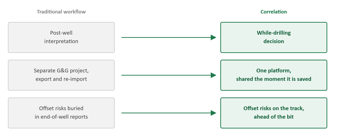
Correlation adapts the correlation workflow to the pace of operations.
n
Related use cases
June 26, 2026
SiteCom: Avoiding the hidden costs of inconsistent data with the GM Hub
June 19, 2026
SiteCom: Real-time gas shift analysis for understanding pressure behaviour in HPHT wells
June 12, 2026
SiteCom: Why real-time data quality monitoring is now a safety-critical function
June 3, 2026
SiteCom Link: Closing the gap between disconnected systems and real-time well operations